|
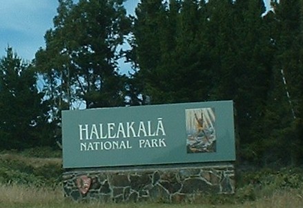
Haleakala
National Park
|
Just a few comments before I start. A lot of
people drive to the top of Haleakala to enjoy
the sunrise. Frankly I was on my vacation and
was not about to get up at 3:30AM to make the
trip from the Lahaina area to the top of Haleakala!
We picked the clearest day of our vacation and
took the drive up and got great views of the island
below all the way up and didn't have to fight
that many bicycle groups on the way down as you
would post-sunrise. Also, if you drive up in the
dark it is more dangerous and you can't enjoy
the trip. Just my personal opinion.
The area now know as Haleakala national park
was originally part of Hawaii National Park and
was redesignated as a separate entity in July
1961 and an International Biosphere Reserve in
1980. More than 80% of 30,183 acres in Haleakala
National Park is designated as wilderness.
Stock your cooler as there are not any places
to buy food within a long way of the summit, and
prepare for a variety of weather conditions. The
weather in the summit of Haleakala National Park
is unpredictable and can change quickly, although
it was quite cold when we were there in late July.
Temperatures in the summit area range between
32oF and 65oF, and potential
wind-chill.
|
 |
 |
I would recommend is to buy one of many CDs available
for your trip. They cost anywhere from $10-$20
and give you a good overview of the trip. You
periodically turn off the guide CD so you don't
have them going on and on so it doesn't get tiresome.
It also allows you to learn more about the volcano
itself and it's place in the Hawaiian mythos.
Stop at the visitors center at the entrance.
There are some interesting exhibits talking about
the history of tourism and the local wildlife.
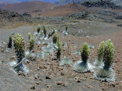
There is also a great example of the Haleakala
silversword plant, which only grows on the slope
of Haleakala. Normally you could not want to get
that close to one of these plants as their small
roots extend as far as six feet from the plant
and are easily damaged by the weight of human
footsteps. More information on Hawaii's endangered
ecosystem is available at: http://www.hear.org.
|
|
|
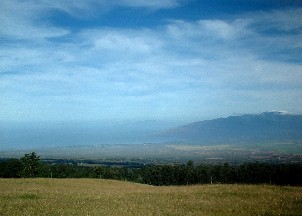
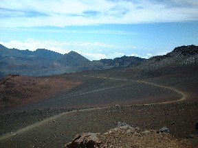
On the way up, be sure to take the time to pull
off and enjoy the view. It is important for the
driver to pull off to the side to truly enjoy
the view since there is more than enough twists
and turns (and not to mention bicycles) to keep
your full attention!
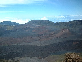
Here are shots at the right looking at the south
end of the island and on the left looking at the
north end of the island. On an exceptionally clear
day you can see almost the entire island as you
drive up.
|
 |
|
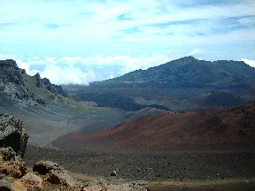
Haleakala is a shield volcano that has been above
the ocean surface for about 1.5 million years.
A surprising thing about Haleakala is that they
actually expect it to erupt again, as it is considered
a "dormant" volcano and not "extinct.
The recent geologic history suggests that Haleakala
erupts regularly every several hundred years.
The last major eruption was detailed in 1790 -
althought that date is a matter of dispute and
could be as far back as 1400 (still a tick of
the clock in geologic terms) - so it may be within
your lifetime!. The eruption is likely to occur
in one of the rift zones along the sides of Haleakala
(as with the 1790 eruption) and will not likely
be in the crater itself
|
  |
|
|
Hiking in and around Haleakala can be a memorable
experience, but you better come prepared! The
elevation makes you tire easily and sometimes
the changes in elevation make a short hike more
tiring that it would normally be. I had a backpack
carrying my 2 year old daughter and it was more
exertion than I bargined for, as I opted for a
nap after returning to our hotel. White Hill trail
at 0.4 miles (round trip) and a 140 foot change
in elevation is a pretty easy hike. Also the Sliding
Sands to first switchback offers some nice views
and is 0.66 miles (round trip) and only a 30 foot
change in elevation. We went almost halfway to
Ka Lu'u o ka O'o from Sliding Sands, the full
trail is 5 miles and we probably saw 2-2.5 miles
of it. Definately worth the time as the view from
inside the crater is certainly more rewarding
than looking down into it.
For the truly ambitious, the National Park Service
maintains three wilderness cabins that you can
hike into. Occupancy is determined via a monthly
lottery system. For more details visit the national
park service website at: http://www.nps.gov/hale/pages/tier_two/cabins.htm.
This is definately on the future agenda as my
daughter gets a little older...
|
|
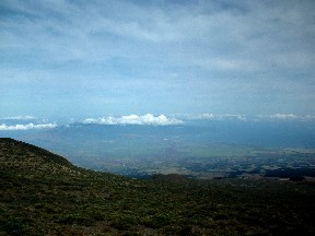
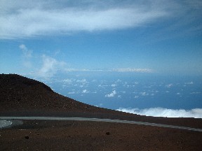
After you get to the visitors center, a lot of
people assume this is the top, however it is just
the best place to view the crater area. Just up
the road is an observation deck at the summit
of approximately 10,023 feet in elevation. On
a clear day you can actually see the volcanos
of the big island. You can't see them that well
in this picture, but I could see them from the
observation deck. To your right you will see what
is commonly noted as Science City. This is a complex
of observatories run by the University of Hawaii
and DARPA for basic research as well as missle
tracking and space surveillance. Some of the native
hawaiians are not very happy with these observatories,
since they are very conspicous and disturb the
natural view of Haleakala from a great distance.
On the way down I suggest that you take your
time, use a lower gear to prevent your brakes
from heating up, and make sure to watch for bicyclists
and others enjoying the view (when they should
pull off the road).
|
|
|